Marrakech – a bonus family holiday in 2007

Targa Sunset, MarrakeshLike waiting for a bus, we were lucky enough to have two hot summer holidays abroad this year. If anyone knows of any good carbon offsetting schemes for all those air miles, just let me know.

House guests of Katie’s family friend Tom Stoddart, we enjoyed the almost surreal luxury of being catered for all week in a beautiful and spacious home in Targa, on the northern suburbs of Marrakech. Tom, is well-off enough to have several domestic employees – all of whom were very friendly and helped us all to feel like we’d mixed with local people. Our French linguistics had to be dusted off a bit and with a strong regional accent, some words were hard to distinguish, but we got by.

The house was made even more child friendly by having a supply of dog and even eight 3-week old dachshund puppies. Olly and Lily made several daily visits to their little den each day.

Although it was lovely to have had a pool all to ourselves and enjoy the children (we went with Katie’s family: Sally, Simon, Olly, Lucy, Jean and Bill), we also had enough opportunities to nip into this amazing city a few times, too.

Marrakech
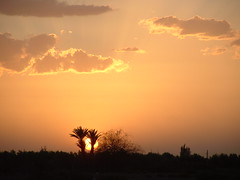
There’s some family photos here and less familyesque photos on Flickr here. The sunsets were particularly enjoyable – even without much immediate topography other than palm trees and olive groves. Simon and Sally’s flickr photos are here.

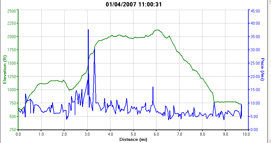
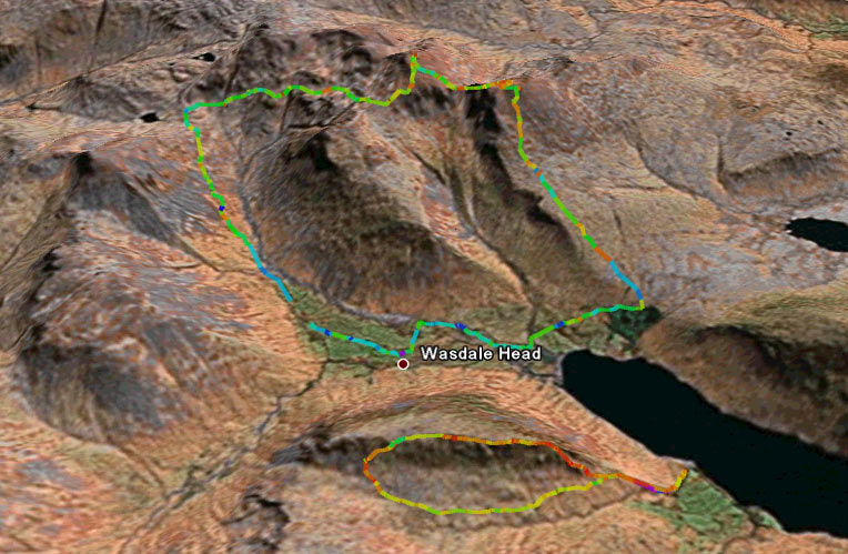
I also managed to keep the training going all holiday and ran each morning for a minimum of 35 minutes in some temperatures that would suggest a lot more lying in bed. The theory was to get up early and get out or get cooked. Daytime temperatures reached the mid 40s on some days but it was only in the high 20s in the mornings. I acclimatised well though, and running was a real joy in such a different environment. Google Earth tracks of the runs from my Garmin 305 are here, showing some nice zig-zagging through the shade of the olive groves and the dusty barren ‘fields’, complete with tumble weed.

Great fun – thanks Tom and we’ll come and see you again when you move to Agadir!

Belmont Winter Hill fell race 2007


Winter HillBelmont Winter Hill race Results now here (PDF) courtesy of Dave Bateson.

I had a great race with less than 24 hours notice it was actually happening (yep – dozy) at Belmont yesterday. An idyllic summer village fête and about 120 runners all togged up in not much. Great classic 4.5 mile fell race starting and finishing on the village playing field. We’re so lucky round here with so many of there going on all the time. I worked hard during the race and felt justly rewarded with a pretty good position. Lacking in some areas, but I enjoy it, and that’s got to be what counts.

View the route in Google Earth: Belmont – Winter Hill Fell Race 2007 Google Earth KML File

Watch willfoxere2k7’s video of the race departure and arrival on youtube (you can see why fell running’s not a TV sport!)

On the road again

I’ve had to change my fitness strategy since leaving my old job and losing the cycle commute, and I’ve started to do a little bit of road racing on the bike again. I’ve been fairly encouraged by the results but not startled. It’s just nice to do something different than cyclocross or fell running. I love both of them, but road racing’s so different.

I’ve also realised that I’ve become more aggressive in my road racing as I get older. I can’t be bothered to mess about slip-streaming and saving my energy for the finale -I’d much rather give myself a good kicking. If I lose a few places in the finale as a result, then so be it, but it’s a lovely thought to hammer yourself in the breaks whenever possible just in case they pay off, which they sometimes just do!

The Bowland Road Race today (Google Earth KML file here) was surprisingly fast for a 3rd category race, 23.9 mph – albeit only over 42 miles. It was hilly and breezy, and fairly relentless. All worked out well though when my team mate Stuart Reid got in the break that worked, and won the race. I finished fifteenth or so. My legs cramped on the uphill finish and that was that. A great, hilly, fast workout though.

Kinder Downfall fell race 1 April 2007

My first fell race since Whittle Pike some eight months ago after a bit of a break from competitive running trying to get my back injury better. I was really very chuffed to finish 11th out of a field of about 250. I was 25th in 2005 (last attempt) in 1:20:06. I covered it in 1:16:25 this time round.

Kinder Downfall fell race profileThe Garmin Forerunner clocked this at 9.71 miles and 1770 feet of ascent and descent. Advertised at 10m and 2,500 feet, there’s quite some difference here, but I trust the Garmin. The start’s almost 700 feet up and Kinder’s only a shade over 2000 feet.

Still – it’s a tough, classic fell race. Faster than many Lake District ones, it’s descents are good under foot, and easy to keep your momentum up without being too steep. There’s a killer (for me) 1.5 mile run in at the end – the type I detest(!), and I annoyingly lost two places here, but that’s the price I pay for being a cyclist who just can’t be bothered to train to run on roads.

View the race route magically trasported from my Garmin Forerunner into Google Earth KMZ here.

Click on the image above for the profile of the route (and my pace along the way in blue)

Spring: fresh air.

Ride!Really feels like spring’s on its way now. It’s a warm, sunny Monday, the clocks have finally jumped into summertime, and people are starting to smile again. I had renewed vigour this weekend after a slight sick bug last week, and had a tough but really enjoyable 3.5 hour hilly ride through Bowland into a fairly relentless headwind on Saturday (even finding the time to take this photo with my new camera phone).

Had a great run up Ingleborough with Elvis on Sunday morning to revive the legs a bit. Views slightly stifled by haze (and a bit windy again), but, as ever, it’s an enjoyable 5.75 mile run.

Here’s links to the Google Earth path files for the ride and the run. The more astute will notice my annoying five mile detour on the ride at Slaidburn, when I wasn’t concentrating and took the wrong turn….!

Howgills, some Sedbergh reminiscing, and an overdue dose of snow

I had a great day out with some soon to be ex-colleagues (and a currently ex colleague) in the Howgills the other day, taking in a 9.5 mile walk in the beautiful Howgill Fells. It enabled me to (fairly) quietly reminisce about my two years living in Sedbergh as a teeneger, especially as we retraced the route of the Sedbergh Ten Mile race on our way back into the town (“Muddy Slide” – a steep gorge – the excitement came rushing back to me).

Look northwestThe snow finally came to the north west for me – our house has had the barest of coverings this winter, much to my disappointment, so to get out in the snow, albeit just a generous dusting, was great.

Piccies on Flickr. Here’s the walk as a google earth (.kmz) path if you’re interested.

Mind blown by GPS data

A few weeks ago, I bought a Garmin Forerunner 201, on a whim, from my friend Matthew. When I bought it, it was very much an experiment to see whether I’d get on with it and get enough out of it.

It comes with some fairly dreadful software that gives you some very basic visual data about your runs / walks / cycles, and the software itself was one of the main reasons I started to think it was not something I’d keep in my possession in the longer term.

However… after quite a bit of ferreting around, I’ve now found the ‘Holy Grail’ – just what I was after. I’ve found a way to export the data from the Garmin LogBook software, then convert this into Google Earth path files (that you can view and save in Google Earth). All this is done through the GPS Visualiser website (BIG credit to them – THANKS!!).

wasdale_weekend.jpgHere’s the type of data I’m talking about… (click on the image on the left). Walking mountain titans of the first weekend in March will probably want to download the walks so they can open and ingest them in Google Earth.
Saturday’s Walk
Sunday’s Walk

Instructions and links for how to do this below. Continue reading “Mind blown by GPS data”