

A few weeks ago, I bought a Garmin Forerunner 201, on a whim, from my friend Matthew. When I bought it, it was very much an experiment to see whether I’d get on with it and get enough out of it.
It comes with some fairly dreadful software that gives you some very basic visual data about your runs / walks / cycles, and the software itself was one of the main reasons I started to think it was not something I’d keep in my possession in the longer term.
However… after quite a bit of ferreting around, I’ve now found the ‘Holy Grail’ – just what I was after. I’ve found a way to export the data from the Garmin LogBook software, then convert this into Google Earth path files (that you can view and save in Google Earth). All this is done through the GPS Visualiser website (BIG credit to them – THANKS!!).
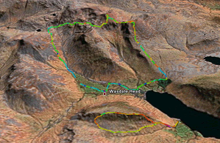 Here’s the type of data I’m talking about… (click on the image on the left). Walking mountain titans of the first weekend in March will probably want to download the walks so they can open and ingest them in Google Earth.
Saturday’s Walk
Sunday’s Walk
Instructions and links for how to do this below.
- Use the Garmin LogBook software (NOT the training Centre software)
- Select File > Export XML
- Split the XML file into individual runs / walks / cycling events using this link
- Upload your run / walk / cycle to this page and select the output file to be ‘Google Earth KML
- Download and save (or directly open) the Google Earth KMZ file (it’s just a compressed KML file), then open in Google Earth.
- If you’re male: Stare in wonderment for hours
- If you’re female: Just say “Oh – that’s interesting”, then immediately move on